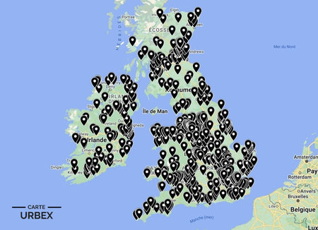
Derby is one of England's great industrial cities — the birthplace of the Industrial Revolution at Richard Arkwright's Cromford Mill, the home of Rolls-Royce and a railway engineering centre that shaped Victorian Britain. Its abandoned places carry that industrial weight: Victorian railway infrastructure, derelict hall wings and the Derbyshire Peak District's abandoned lead and copper mines. Here are 5 of the best abandoned places in Derby, selected from our Abandoned Places Map UK — 640+ GPS locations across England, Scotland, Wales and Ireland.
Why Derby Is a Hidden Gem for Urban Exploration
Derby sits at the gateway to the Peak District — which means the abandoned lead mine infrastructure of the Derbyshire limestone plateau is within easy reach of the city's own Victorian railway and civic heritage. Few English cities offer this combination of urban dereliction and rural industrial ruins within a single day trip. The Derwent Valley corridor alone contains multiple UNESCO-listed sites alongside genuinely unexplored abandoned mills.
1. Friar Gate Railway Bridge and Goods Yard – Derby — Victorian Cast-Iron Viaduct, Grade II Listed, Derelict Goods Yard, Central Derby (Known Location)
The Friar Gate Railway Bridge is one of Derby's most distinctive Victorian landmarks — a decorative cast-iron viaduct carrying the Great Northern Railway's route through the western edge of the city centre. The adjacent goods yard served Derby's Victorian commercial economy for decades before declining railway freight made it redundant. The Grade II listed ironwork viaduct, the overgrown goods yard tracks and the urban setting in the heart of Derby make Friar Gate one of the most accessible abandoned railway heritage sites in the East Midlands.
🔗 Learn more: Wikipedia – Friar Gate Bridge Derby
2. Allestree Hall – Allestree, Derby — Grade II Listed Georgian Hall, Empty for Decades, Parkland Open to the Public, 3 Miles from Derby City Centre (Known Location)
Allestree Hall is a Grade II listed Georgian country house standing empty in the public parkland of Allestree Park, three miles north of Derby city centre. The hall has been empty for decades, various restoration plans proposed and abandoned as the structure slowly deteriorates. The Georgian architecture, the public park setting and the visible decay through the windows make Allestree Hall one of the most accessible and most striking abandoned country houses in Derbyshire.
🔗 Also read: Top 5 Abandoned Places in England →

3. Abandoned Derbyshire Lead Mine – Peak District — Georgian-Era Engine House and Buddle Pit Still Intact, Limestone Gorge Setting, Matlock Bath Area (Exclusively on Our Map)
A Georgian-era lead mine in the Derbyshire Peak District limestone country — the original engine house chimney still standing above the gorge, the buddle pit where crushed ore was separated by water still visible and the mine shaft infrastructure cut into the limestone hillside. Derbyshire's lead mining heritage stretches back to Roman times; the Georgian-era operations left extraordinary infrastructure across the limestone plateau that has been decaying since the industry collapsed in the late 19th century. Discover its exact location on our England Urbex Map.
4. Abandoned Derwent Valley Textile Mill – 1860s-1880s Mill on a Derwent Tributary, Cast-Iron Columns and Mill Race Still Visible, Belper Area (Only on Our Map)
An 1860s-1880s textile mill on a Derwent Valley tributary — the original multi-storey mill building with its cast-iron structural columns, the mill race channel cut along the river bank and the loading dock infrastructure of a mill within the Derwent Valley Mills UNESCO World Heritage landscape. When cheaper production ended the mill's viability, the structural shell was left in place with the riverside setting intact. GPS coordinates available with our England Urbex Map.
5. Abandoned Peak District Gritstone Farmstead – 17th-18th Century Longhouse, Cattle Byre and Living Quarters Under One Roof, Field Barn Still Standing (Our Map Exclusive)
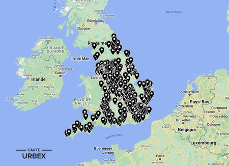
A 17th-18th century gritstone farmstead on the Peak District edge — the original longhouse with cattle byre and living quarters under one continuous roof, the field barn with its hay loft and the drystone walls of the intake fields still defining the farm's original boundaries. Peak District farms of this era were built to last centuries; when consolidation and agricultural decline emptied them, the gritstone construction preserved them. Included in our England collection — 400+ locations.
Safety Tips
- Lead mine shafts: the Derbyshire Peak District has thousands of unfenced vertical lead mine shafts, many hidden by vegetation — never approach any depression in the ground near limestone plateau sites
- River levels: Derwent Valley mill sites flood rapidly after rain — always check the river level before entering any mill building with a ground floor adjacent to the watercourse
- Never explore alone — Peak District sites often have no mobile signal; always leave your exact location with someone before setting out
The urbex code: The urbex code: "Take nothing but photographs, leave nothing but footprints."
❓ FAQ
What is the most famous abandoned place in Derby?
Friar Gate Railway Bridge and Goods Yard — a Grade II listed Victorian cast-iron railway viaduct in the heart of Derby, with the adjacent derelict goods yard that served the city's Victorian commercial economy. One of the most accessible pieces of abandoned railway heritage in the East Midlands.
What is Allestree Hall?
A Grade II listed Georgian country house standing empty in Allestree Park, three miles north of Derby city centre. Empty for decades, freely visible from the surrounding public park while various restoration plans have come and gone.
Why does Derbyshire have so many abandoned lead mines?
The Derbyshire limestone plateau has been mined for lead since Roman times. Georgian and Victorian industrialisation scaled up extraction significantly; when cheaper imported lead undercut English production in the late 19th century, Derbyshire's mines closed almost simultaneously.
🎯 Summary
Derby's abandoned places range from a Victorian railway viaduct and goods yard in the city centre to a Georgian hall standing empty in a public park and Peak District lead mines in dramatic limestone gorge settings. Each of these 5 derelict buildings in Derby captures a different layer of one of England's great industrial cities.

Abandoned Places Map England
- ✓ 400+ GPS locations across England
- ✓ Exclusive locations not found anywhere else
- ✓ Instant access after purchase
- ✓ Free updates forever
14,99€
Explore All Locations →